
Hawaii County Neighbor Record Map
Official sources describe parcels, mailing parties, recorded instruments, voter status, and civic activity. None is a complete list of Hawaii County neighbors. Start by deciding whether “around” means a shared parcel boundary, the opposite side of a road, a condominium project, or a short radius. That definition prevents a large farm lot or curved rural road from turning a block search into an arbitrary list.
| Source | What It Shows About a Block | Access |
|---|---|---|
| Planning GIS parcels | Parcel shapes, TMKs, zoning, and visual adjacency | Free public Web Map; informational, not survey-grade |
| Tax & Revenue roll | PIDN, parcel, mailing name, property location, and amount due | Free current search by parcel, address, street, or mailing name |
| RPT surrounding-owner output | Owners and property addresses around a selected parcel | County workflow with Excel or Avery 5160 output |
| Public voter list | Name, district or precinct, and voter status only | Election-law access; private affidavit fields excluded |
| CDP and public packets | Community areas, meetings, groups, and public contacts | County planning and records repositories |
The tax “Mailing Name” can be an owner, trustee, company, agent, or other recipient. The “Location” is the physical parcel label. A BOC grantee has a recorded property role, not automatic proof of occupancy. Hawaii’s public voter list is also narrow: affidavit details such as residence, birth date, identification, phone, email, and signature are restricted. Report only the role each source proves.
Define Hawaii County Neighbor Parcels
Two lots that share a boundary are adjacent. Lots across a road may feel like the same block but do not touch. Condominiums can place many units on one land parcel, and large agricultural tracts can border a home while their mailing parties live far away. Draw the rule before collecting names: shared edge, road-facing parcel, or a fixed visual radius. Then apply it to every side of the target.
Use the Hawaii County Planning GIS to inspect parcel polygons and TMKs. Layer dates vary, and the map is not a legal survey. A boundary that looks close on screen may follow a road easement, stream, or common tract. Save the source date and parcel number rather than relying on a screenshot alone.
Export Hawaii County Neighbor Records
Hawaii County publishes instructions for creating a surrounding-property-owner list from Real Property Tax results. The output can include the TMK, owner, and property address, then export to Excel or Avery 5160 mailing labels. That feature is useful for a defined notice area or careful block inventory. It is not an occupant directory. A mailing address elsewhere on the island, out of state, or under a trust name is evidence about tax correspondence only.
Open the official surrounding-owner instructions, then compare its output against GIS. Search any missing adjacent parcel one at a time in the Tax & Revenue portal. Preserve the parcel, location, mailing name, and check date as separate columns.
Note: A surrounding-owner export identifies tax-roll parties, not every adult, child, guest, renter, or current occupant on the block.
Map Hawaii County Neighbors Outward
Move outward from one verified parcel. Hawaii County Planning notes that some TMKs must be entered without the leading island-zone digit, so retain both the full tax number and the map-entry form. Do not jump from a street name to every matching address. The parcel is the stable link among GIS, taxes, recorded instruments, maps, and public notices.
- Search the address in Planning GIS and confirm the target parcel, TMK, and road.
- Mark every parcel that fits the chosen adjacency rule. Note roads, common areas, and multi-unit parcels.
- Open each parcel in Tax & Revenue. Keep the mailing party separate from the property location.
- Use the surrounding-owner output as a cross-check, then research any omitted parcel on its own.
- For a whole named road rather than one block, move to the street-by-street workflow.
The Hawaii County street directory follows the longer address chain when the question expands beyond immediate neighbors. For a block search, stop at the boundary defined at the start. That keeps the work focused and reduces the risk of turning a civic or property question into needless collection about private people.
Hawaii County Neighbor Street Context
The County centerline stores road names, aliases, address ranges, left and right ZIP fields, districts, approval years, and subdivision or resolution references. It also warns that rural, private, new, or renamed roads can be incomplete. A geocoder match is approximate and informational. If GIS, the tax location, and the supplied address disagree, preserve all three versions and date them.
Street continuity rules can also make a nearby lot appear under another road name. County ordinance addresses duplicate names, continuity, and renaming, while the centerline can preserve an alias. USPS verifies postal formatting and ZIP context, but it does not confirm a person or company at an address. The mismatch itself may reveal a private road, subdivision label, old name, or source-date difference.
Hawaii County Neighbor Contacts
Hawaii County uses Community Development Plan, or CDP, areas and Action Committees instead of Honolulu-style statutory neighborhood boards. Official planning contexts include Hāmākua, Kaʻū, Kona, South Kohala, North Kohala, Puna, and Hilo. These bodies provide meeting contacts and civic geography. They are not directories of neighbors or association members.
CDP Action Committees
Use County Planning for community-plan areas, public meetings, and official contacts.
Boards and Commissions
The County civic directory lists public bodies and appointments, not household rosters.
Public Meeting Packets
Packets mention Hakalau Neighborhood Watch, Hanamalo Loop Homeowners Association, and Waimea Community Association in context.
A 2024 County planning packet explains that “neighborhood board” is a Honolulu-program term, not Hawaii County’s statutory model. Aha Moku councils serve cultural and resource consultation roles and likewise are not a modern resident lookup. Contact a group through its public meeting record instead of seeking a private membership list.
Hawaii County Neighbor Voter Limits
Hawaii law makes a limited election list public: name, district or precinct, and voter status. The registration affidavit’s residence, birth date, identification number, phone, email, and signature are restricted except for election or government purposes. The Online Voter Registration portal is for a voter to register, update, or confirm that voter’s own record. It is not a public address search for nearby households.
A district or precinct can give broad civic context, but it does not prove a block address. A missing name also proves little. Registration may be inactive, the person may not be eligible or registered, or an address protection may apply. Never fill that gap with an inference from another source.
Compare Hawaii County Neighbor Tools
Official records are narrower than commercial neighbor-search products, but their limits are visible and their custodians can correct errors. Commercial tools often merge names, phones, and old addresses without showing the source date. Use them neither as proof nor as a substitute for a parcel, recorded instrument, or lawful civic contact.
| Source type | Strongest use | Main limit |
|---|---|---|
| County parcel and tax records | Defined land, mailing party, and current location label | Does not prove occupancy |
| County civic records | Public groups, meetings, plans, and contacts | No private member directory |
| Commercial category | Possible lead to verify elsewhere | Opaque merging, stale data, and uncertain roles |
For Hawaii County neighbors, use a source that answers the exact question. GIS answers which lots touch. Tax records answer who receives parcel mail. Public packets answer which groups took part in a meeting. None answers every household question.
Hawaii County Community History
County cemetery folders can connect an older community name with a cemetery, person, plot, burial date, and plot status. They are useful for neighborhood history, especially where road and postal labels have shifted. The published sets cover named county cemeteries, not every burial ground on the island.
The Hawaii County burial-information folders are shown below. Their local place names can help explain older records near a parcel without turning a burial record into evidence of present residence.
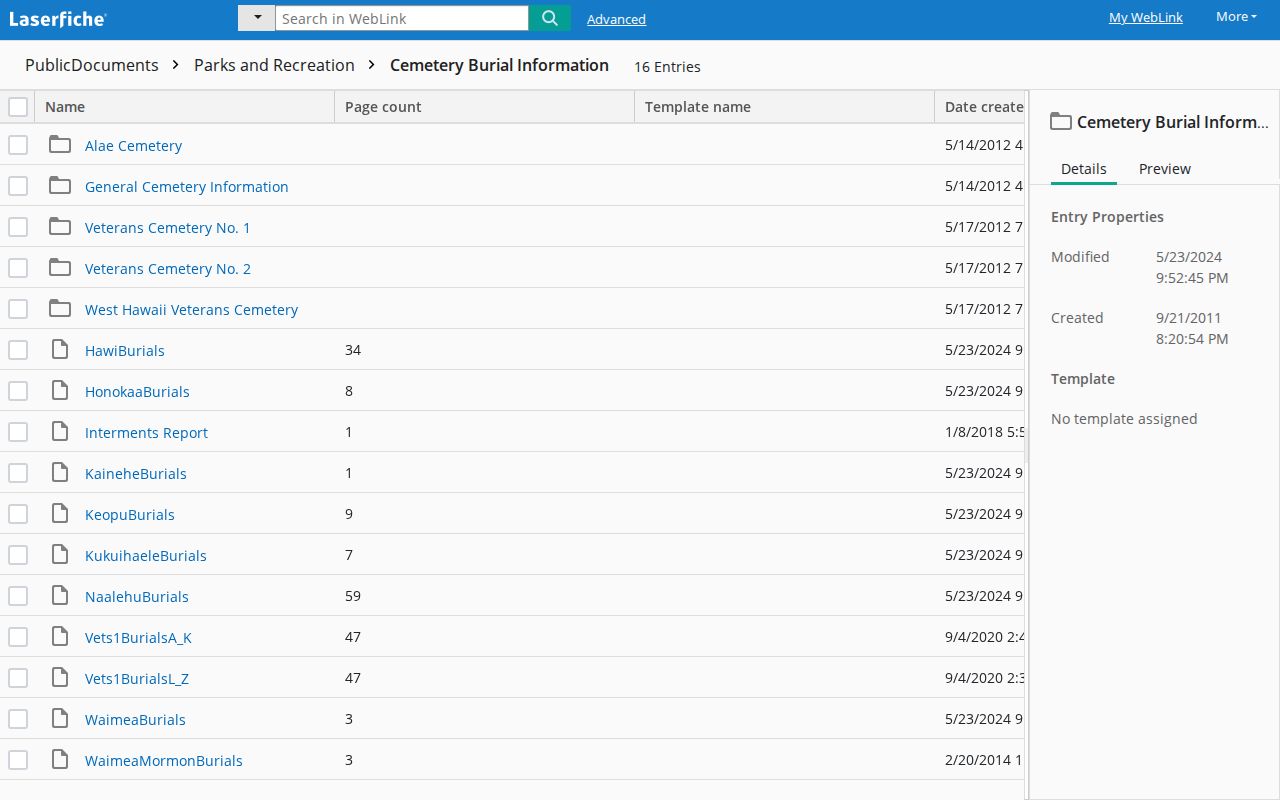
Use County Parks for a missing or unclear cemetery entry. Keep this historical layer separate from current neighbor research.
Protect Hawaii County Neighbors
Parcel and civic records do not open every detail about a block. Utility and delivery data are not public neighbor rolls. Vital records remain restricted by eligibility rules. Hawaii’s Address Confidentiality Program gives eligible survivors a substitute address and mail forwarding, and state law bars unauthorized release of a participant’s actual address. Certain public servants have added protection for home and family details.
Absence from a portal is not evidence that someone left. A record can be suppressed, delayed, indexed differently, or held outside the online window. If an official record is wrong, contact its custodian about correction. The Uniform Information Practices Act can request an existing non-exempt agency record, but it cannot override a specific privacy law or require the County to create a private-person dossier.
Keep names out of public notes unless the research purpose requires them, and retain the parcel number, source, and date instead.
Lawful use. Research Hawaii County neighbors for civic contact, property questions, reconnection, or personal safety. Never use public records to watch, intimidate, harass, or harm anyone.